 |
 |
 |
 |
 |
 |
 |
 |
 |
 |
 |
 |
 |
 |
 |
 |
|
|
|
|
|
|
|
|
|
|
|
|
|
|
|
|
|
Grateful thanks to all those that have provided many of the articles, references and details in these pages
This is a non-profit site |
| |
| |
| |
| |
| |
| |
| |
|
|
The Archeological Evidence
 Time Team, a programme of archaeology on Channel 4 television, was to be an opportunity that was not going to be missed. It had become very popular, putting archaeology on a more approachable footing. Time Team, a programme of archaeology on Channel 4 television, was to be an opportunity that was not going to be missed. It had become very popular, putting archaeology on a more approachable footing.
Every Sunday evening on Channel 4, avid amateur armchair archaeologists watch week in and week out, to see what wonders lay under a wheat field or road development or even just someone's back garden. The programme has been running for many years. On a number of occasions they organise some kind of special dig that is transmitted live, bringing the intricate historic finds right into our own homes, thanks to the wonders of television.
In the spring of 2003, Channel 4 were starting to organise Britain's largest archaeological dig. It was going to be live over a whole weekend with ordinary people digging in their back gardens. But there would also be a possibility for some to venture a little further, digging on public land - as long as they sought permission first.
This was it - the opportunity we had been waiting for. It was decided that the Orpington Astronomical Society should get involved. Time Team had given a glimmer of hope. It meant the OAS could dig into the Wandsworth Common to find what remained of the Craig Telescope!
back to top of page >>
|
|
 |
|
|
|
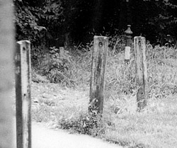
Three posts thought to be associated with the telescopes circular outer rail.
courtesy Stuart McLaughlin |
|
|
|
Some years ago a visit by Stewart McLaughlin a member of the British Astronomical Association revealed three short posts placed in the pavement near the junction of Lyford Road and the path at the back of gardens in Routh Road. It appeared these might be parts of the 32 metre diameter outer rail of the Craig Telescope, however, the Roads Department at the Wandsworth Council made assurances that these had nothing to do with the telescope and had been removed from the roadside paths in a clean up operation to remove footpath "clutter".
It is an interesting fact that at the site, and one has to assume that this was the case at the time of the telescope, the land slopes slightly downhill from west to east. In all the engravings and illustrations the outer rail is shown as being more or less level with the ground – inlaid perhaps. However, if this indeed was the arrangement it must have caused many problems. Stones and gravel would have plagued the smooth running of the azimuth motion. Making sure the eyepiece did not move up and down when observing - even by a small margin - must have also been a problem!
The lie of the land just here would have given Mr Craig excellent uninterrupted views of the sky. London lay to the north, while the small town of Wimbledon was a short distance to the south. The "docks" of Wandsworth, just a mile or two north, would have made the transportation of, say, the telescope's long tube, very easy. London Town had ample rail links to many of England's large towns.
The bricks for the central tower of the telescope did not come from the same source as those of the Wandsworth Prison built only a few years earlier. These had come from the Frying Pan Brickworks not far from the site. A cursory investigation of the site in September 2003 showed no sign of any bricks although this may simply be because of the amount of overgrowth.
An article written in 1856 mentions, "...surrounded by a wooden hoarding to keep off intruders". The fence shown in the engraving in the Illustrated London News was drawn from a daguerreotype photograph and so would suggest that the perimeter fence did exist.
Using some old maps, especially one created in 1856, not only is the two acre plot marked, but also a dark spot with the word "Observatory" written above! It is worth mentioning the two buildings on the northern boundary - each appear to be about half the size of present housing in Routh Road. The 1870 map reveals no "telescope" marking. It may be that the telescope had been either removed or was in such a state as to be unrecognisable for any particular purpose.
back to top of page >>
|
|
|
 |
The present day Ordnance Survey map shows the modern day sprawl of the housing now occupying this part of the common. The properties in Lyford Road were built at the beginning of the 20th Century, while those in Routh Road are of a slightly earlier period. Notice, also, the positioning of the trackways crossing the common from one map to the next, this may help in pinning down the tower's location. Notice also the elevation contours showing the 30-metre height of the ground. The highest part of the site is the northwest corner, although not by much.
The aerial photograph only goes to show how much the vegetation and foliage has grown up since the days of the ‘scope, when all that was there was more or less gorse and brambles.
back to top of page >>
World War II
During the Second World War, Wandsworth was subject to many high-explosive bombs during German air raids on London. It was important to see whether any of the bombs had destroyed the remains of the Craig Telescope. From a map of bombing raids during WWII, found at the Wands worth Reference Library, it was obvious that no damage was done to this particular part of Wandsworth Common. However, a metal detecting survey conducted in mid-June 2003 of the whole site showed there were plenty of pieces of shrapnel that had been scattered over the whole area.
back to top of page >>
Other building work
From all the studies to date, no other building work has ever been carried out on the site before or after the Craig Telescope.
Field Walk
The field walk was carried two weeks before the dig in association with the metal detectorist survey and produced a mixed bag of finds lying either on just under the surface. These have been clearly marked on the map. One interesting point was that there were no Victorian coins found, although there was a dog tag but no dog attached!
back to top of page >>
Preliminary Surveys
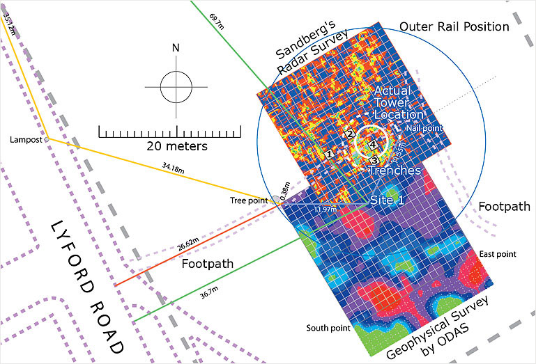
The first 20-metre x 20-metre survey was undertaken on the common by the Orpington & District Archaeological Society (ODAS) early June 2003. After many hours of pondering over the maps and intuitive "best" guesses, an area in which the survey was to be conducted was placed on the site map. It was essentially placed over the part of the Stanford 1856 map that contained the telescope tower as marked. The argument that Mr Stanford may have at least placed the tower in roughly the right position at this scale, was based on nothing more than if he were simply just to put it in the two acre site not knowing anything about the project, he would have probably placed it in the very centre. This is not the case. The tower is marked towards the south of centre. Does this make sense? The lie of the land shows that the most level part of the site is near the centre but taking into account the outer rail, placing the telescope slightly further south provides a greater amount of level(ish) ground.
The whole area near where the proposed survey would be done had to be fully measured out, so that any future surveys could be placed down just as accurately. A point on the ground near a dying tree was chosen as the "triangulation" marker. From here, all other markers would be gauged. It became known as "Tree Point" and was exactly 26.62-metres from the pavement edge in Lyford Road.
On the attached map the "resistance" geophysics map is marked, showing it relative position to that proposed in Stanford's map.
The nature of the ground near this area is very overgrown with stinging nettles, brambles, grass, bushes and trees. However, despite this difficulty the survey was conducted well.
The results were fairly inconclusive because of the high resistance signals recorded. Indeed the only conclusion that was reached was that something very reflective lay under the ground. Dr Alan Hart of ODAS and the survey's leader suggested it may be the signature of gravel beds or concrete. Unfortunately, after the purchase of a geological map of the area from the Ordnance Survey, it revealed that the whole area around Wandsworth Common was covered, just under the topsoil, by a layer of the Lynch Hill Gravel beds. This was not a good result for the "resistance" geophysics.
A metal detectorist was persuaded to carry out a survey that covered Craig's original two acres. This proved quite useful in that it picked up a number of artifacts some associated with WWII and others from interesting and as yet unexplained sources. No doubt some of the finds near Lyford Road may be attributable to the building of the houses there in and around 1910. The metal detectorist's opinion of the site was interesting - suggesting it did not look as if any demolition had taken place or if it had it had been well cleared away.
back to top of page >>
Ground Penetrating Radar
Because of the inconclusive results of the "resistance" geophysics, there was an urgent need to exploit another method of non-destructive surveying – radar. Ground Penetrating Radar (GPR) uses radio waves to investigate underground stratas. After several frantic phone calls, Sandberg, a GPR company in Clapham said they would conduct a survey for our dig team.
|
|
|
A detailed map of the Craig Telescope Dig Site. It shows all the reference points relating to fixed points in the terrain. The Orpington and District Archeological Society carried out the geophysics survey shown towards the south of the Sandberg radar survey. The small gridded squares are each 1 metre across.
Courtesy © Greg Smye-Rumsby
See maps of the area through the years>>
|
|
|
|
|
| |
 |
|
|
| |
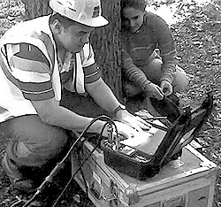
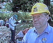
Seeing the tell-tale signs, Rachel looks on as a Sandberg engineer checks the data. |
|
|
Two days before the Big Dig weekend, the GPR survey was undertaken. This survey was undermined by the terrain on the common, so we knew the results might be difficult to interpret. This second 20-metre x 20-metre survey was moved 5-metres east and 15 north of the "resistance" geophysics survey. This move was intuitive, based only on the higher levels of resistance recorded at the northern edge of the first survey results, so if there was anything beginning to show up it would be more likely to show up in the new survey. It also meant that there would be a 5 x 15-metre overlap on the two surveys.
The results of the GPR were expected by late Friday – they came in on time. It was, as expected, not clear. One of the key positions under investigation did not show up well at all, while an area around a huge acacia tree showed up as a clear possible target despite the tree roots.
With all the survey data in it was time to make some judgments about the actual dig itself – where to put the trench. We only had a small window of opportunity and we had to make it count.
|
|
 |
|
|
|
Getting ready for the first trench
courtesy Tony Buik |
|
|
|
The site was divided into three target sites. "Site 1" was placed right over the centre of the dot marked on the Stanford Map. Since this site revealed little during the first tentative explorations it was not going to be investigated with a trench.
"Site 2" was the smaller of the circular features that showed up on the GPR. This would have placed the telescope tower very close to the eastern limit of the Craig Telescope site – but it could fit – just.
"Site 3" was the area a little south of the huge acacia tree. This is where the trench was going to be put.
back to top of page >>
The Excavation
Saturday morning – 28th June 2003 - very early, the site was marked out. When all the lines had been staked out it resembled a life-sized version of the computer model map that had been constructed for the purpose. All the "Sites" were now clearly identified. Almost immediately, the "dig" square metre that had been chosen to coincide with the grid on the map was marked out. The area cleared of the long grass and so the dig began.
|
|
|
 |
|
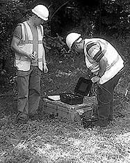
| Checking the equipment shortly before the radar survey. |
|
|
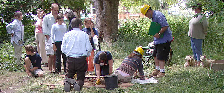
Using spades to cut off the top layer of grass roots the dig proceeded using small pointing trowels stopping frequently to record any finds. The spoil was piled onto a large clean tarpaulin some metres away to the south east. Each bucket of spoil was sieved for smaller finds not spotted during the dig.
|
|
 |
|
|
|
Getting ready for the first trench
courtesy Tony Buik |
|
|
|
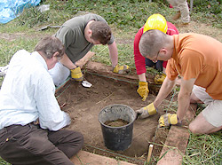
"Site 3" trench 1 proved to be just as difficult as the survey. The first "context" had to be cut into hard London clay type soil impregnated with small pieces of flint. We knew at this point the dig would take a little while.
By the afternoon on the Saturday, it decided to open a second trench on a new site not marked out on our map – "Site 4". This was a very interesting development. While we were digging the first trench on "Site 3", the activity of all the people trampling the rough grass slowly revealed a shallow circular depression in the ground. This was measured. It was about 8 metres in diameter. If this had anything to do with the telescope – it was perfect!
Once a quick survey had been done the centre of this depression had been located – almost exactly in the middle of the rough footpath from Lyford Road.
|
|
 |
|
|
|
Metal finds - such as nails
courtesy Tony Buik |
|
|
|
So at a distance of 7 1/2 feet and once again matching the grid, a trench was marked out. Digging began. At this point our resources were very stretched.
Because "Site 3" trench 1 had revealed little in the way of finds once "context" three had been completed it was decided to stop digging. It seemed that the soil in this trench was natural undisturbed London clay. One interesting feature of this trench was a large lump of what appeared to be "ferro-crete" a natural very hard concrete welded together with some kind of rust!
"Site 4" trench 1 was also becoming less interesting as the digging progressed. By Saturday evening, two trenches had been dug, one to three "contexts" the other to two. Both had revealed a limited amount of information, but it was quite important. The quantity of brick rubble was much less than expected even allowing for the fact that we might not have hit the absolute centre of the tower's location. The bricks were predominantly rusty-red and there were very few bits of mortar or concrete chippings.
For safety reasons, the trenches were back filled overnight.
|
|
 |
|
|
|
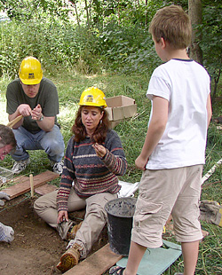
Showing finds to the local community
courtesy Tony Buik |
|
|
|
Sunday was a different day. Another early start. Some of the helpers from the previous day were to return, assisted by new interns.
Both "Site 3" trench 1 and "Site 4" trench 1 were left alone. A new trench was opened – "Site 4" trench 2. This was proposed as a possible corrective action, based more on the "resistance" geophysics map.
Certainly the first three "contexts" proved fruitful with many more finds per "context". They were similar to those found in the first two trenches – bricks, charcoal, glass etc, but just in greater quantity.
By the afternoon, a last trench was proposed – "Site4" trench 3. This was going to be a disappointment, not because we didn't find anything, but because we could not finish it – we ran out of time.
It actually proved to be the best. It was sited two meters north east of "Site 4" trench 2, very close to where the depression would suggest the outer wall of the tower might be. By digging it so close to "Site 4" trench 2 it might be possible to understand what lies under the ground better.
back to top of page >>
The Finds
The finds ranged from brick fragments to small pieces of what appeared to be charcoal. Once all the various fragments had been catalogued and recorded it was noticeable how little evidence there was that there had been a large brick tower on the site. Overall it was expected that once the first trench had been put into the ground that there would have simply been more material. The total amount of finds only weighs 4.01kg! Nearly all of the brick was PMS159 in colour – a dull rusty red.
back to top of page >>
"Site 3" Trench 1
|
|
 |
|
|
|
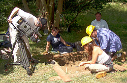
Channel 4's Time Team were there to film all the action as it happened
courtesy Tony Buik |
|
|
|
Because this was the first trench the recording was excessive. Every tiny little mark, blemish, bump or find not matter what, was recorded. Later on in the dig the recording was more "filtered" and less "excited". Apart from the finds the trench contained an unexpected find a large piece of natural concrete. According to our site archaeologist, this is sometimes referred to "fero-crete" – a conglomeration of flint "welded" together by some natural agent; in this case it seemed like rust. The "fero-crete" lump was mistaken for part of the foundations of the tower. It extended from context 2 through to context 3 and beyond. It was left in situ in the trench. As this was our first trench everything was new to us, but it was becoming obvious that there was definitely some association with building work having been done near here – little bits of reddy brick and very, very small pieces of brick that simply could not be picked up, but made a small smear as the trowel was dragged over the surface.
 During the sieving exercise a small metal "button" was found although as to whether it really was a button or just a piece of rusty metal we do not know. During the sieving exercise a small metal "button" was found although as to whether it really was a button or just a piece of rusty metal we do not know.
This trench contained the most amount of square sided nails reminiscent of floor board nails today – one was very large, cut short probably by its removal and slightly bent at the broken end.
The trench's cross-section was a little confusing. Since we had found finds in the trench it was expected that the natural "layering" would be disrupted. However, on all four sides the section showed a relatively complete set of layers. Grass at the top. Next a tree loam mulch soil. Then London clay on top of a layer of well compacted flint about 100 – 150mm thick.
Since London clay had been reached and there were no more significant finds found, the dig leader decided to not dig the final context.
"Site 4" Trench 1
This trench was cut into the northwest side of the circular depression, named on the Saturday as "Site 4". As a consequence, the trench's mean "context" reference was taken as being halfway up the sloping side.
This proved an interesting trench. There seemed to be more of the brick dust that was seen five metres to the southwest in "Site 3" trench 1. Context 1 revealed some floor board nails.
Because of the slightly awkward placement of this trench the contexts were becoming a little shallow, so for clarity "contexts 3 & 4" have been merged into one record – "context 3".
 |
|
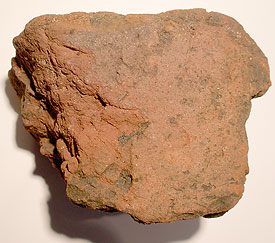
Although few and far between, there were one or two finds that were proof of the telescopes existence. Here are several pieces of masonry - perhaps roof tiles - that belonged to the Craig
Telescope.
courtesy Tony Buik
|
Overall this trench proved a little disappointing, as the expectation of finding something significant was palpable. However, it did confirm yet again that there was some kind of building remains embedded into the surface soil layers.
back to top of page >>
"Site 4" Trench 2
On the Sunday morning a regrouping took place. Since the first two trenches had reveal less than expected in the way of finds a decision was taken to open yet another trench – but where? Looking back at the original surveys, especially the geophysics, it was seen that on the northeast side of the survey, the levels of resistance measured were significantly higher than elsewhere. So a trench was placed right into the heart of that location.
Trench 2 on "Site 4" was very telling. It revealed the very first piece of mortar, something that had not been seen up to this point. It was only 10-grams, but it was mortar. It seemed quite modern not like the lime cement mixtures of the past.
Like "Site 4" trench 1, there was also tile. The two similar pieces were large and thick. They were red in colour but not complete enough to tell how big the final tiles would have been (although the larger piece did seem to one complete side = 111mm [4 1/4-inches] – very difficult to tell). The tiles were both 11mm thick and had similar markings on. The colour of the tiles were similar although the smaller one was slightly darker than the other. The big tile was PMS159 the smaller PMS470.
The brick was similar to before. Small broken pieces. But once again not as much as expected.
Interestingly, no nails were found.
Noticeably, there were what appeared to be broken modern drainage ceramic pipes.
back to top of page >>
"Site 4" Trench 3
The last trench was a final attempt at locating the buried remains of the tower's foundations.
"Context 1" revealed our first pieces of ceramic finds. These were two small pieces of ochre yellow pottery. They had brown painted marks on them as if a tool had been dragged across the surface while the glaze was wet. The glaze was only on the "inside" curve. The pottery fragments were of light coloured clay (PMS155). By pressing the small curved pieces onto the rim of several reference bowls it was possible to guess at the size of the original, about 200 – 230mm in diameter having a thickness of 6mm.
Another tiny fragment of pottery was also found. It was glazed on both sides. The clay was almost white about 3mm thick. The glaze on the "outside" edge was white. That on the inside was a "mottled" blue (similar to PMS Reflex Blue) and white.
There was lots of mortar here. One particular piece is of interest. It was laying down in "context 2" as if it was the start of the foundations we had been looking for. Unfortunately, it was not what it seemed. Once the piece had been carefully removed it was found to be a cement render to a wall. This is interesting because up till moment the tower's outer appearance was always assumed to be brick despite the poor quality of any illustrations from past publications. Now it seems the tower may have been rendered. Sadly the small size of the mortar pieces does not reveal any curvature. In the largest piece there are small brick remnants of the same colour as the other brick finds. The render on the brick face is interesting. Clearly there was a rough render that filled up the uneven brick surface (5 – 15mm thick) applied to the bricks, followed by a fine more carefully applied out render about 6-7mm thick. No evidence of paint on the outside surface was seen. There was also some evidence of a courser sharp sand cement mix being used on the same site. One piece is obvious others less so.
In the trench a single horses tooth was found in "context 2"! It certainly looked as if it had given the animal no end of trouble and pain.
This trench also had the most amount of brick fragments, some large. They varied in colour. Some were a yellowy colour (PMS131), some were darker and browner (PMS160- PMS1535). But the dominant colour of the brick pieces was red (PMS159 – PMS174).
The largest piece of brick (PMS174) reveals some data. Of the two dimensions that can be measured the brick was 65mm x 73mm. The other dimension was probably the longest.
No bricks had any mortar fragments attached. Also none of the bricks samples appear to have been broken deliberately by being struck with a cutting tool.
back to top of page >>
| |
|
As the dig progressed so interest grew from the local community eager to understand more of this forgotten folly.
Courtesy © Tony Buik
|
|
|
 |
|
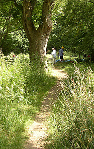
Looking from Lyford Road, the unmade path leads directly over the centre of where the original tower used to stand.
Courtesy © Tony Buik |
|
|
 |
|
During the actual dig, channel 4 were eyeing our progress with great interest.
Courtesy © Channel 4 |
|
|
|
|
|
 |
|
 |
|
|
|
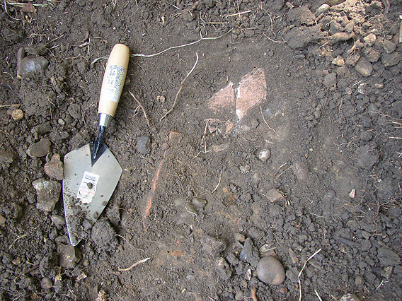
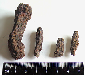
The only iron artifacts - nails - in the right context to suggest these are associated with the telescope.
Click here to enlarge>> |
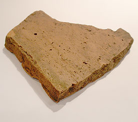
|
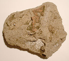
One of the only larger pieces of mortar found. The nature of the trenches precluded an easy identification of very small pieces of mortar.
Click here to enlarge>> |
|
|
|
Conclusions
The dig was a great success. No we did not find any solid remains in position such as walls or foundation concrete. What we did find was an interesting story of demolition and removal.
The finds show that there was a building on this site. It was centred very close to where we had finished off the dig with the fourth and final trench.
The finds themselves reveal several possibilities as to how the tower may have looked. It seems it was partly rendered with a mortar/cement mix. Bevington's photograph shows there was no rendering on the outside but there may have been some on the inside walls or around the windows. The bricks varied in colour from ochre to red. They were house sized bricks.
Also, since we did not find as much material as expected, it seems as if the demolition process removed everything from the site – the whole tower including any underground footings were removed - the site almost swept clean!
The conclusion about the foundations is also drawn from the finds. Since there was a complete absence of concrete chippings there could not have been a solid foundation in place. Even if the concrete foundations had been removed there would have been ample chippings coming up in all areas of the dig.
The 5-metre depression centred on the pathway directly in line with Frewin Road seems to be associated with the removal process.
When the metal detectorist said he did not feel this had the hallmark of a demolition he may have been closer to the truth than originally thought in coming to that conclusion.
An alternative possibility is that when the dig leader stopped digging in the first three trenches it was because in his experience the diggers had reached "natural", this may not have been the case and this ground/land deception prevented the dig uncovering even more – although the finds had petered out in the first few contexts.
back to top of page >>
The Future
It may be that a return to the site armed with this information might reveal more remains some of which might be crucial to a better understanding of the leviathan telescope. There might also be value in exploring the north of the site where the astronomers house was built.
Also armed with this information it would be possible to better understand where to place the exploratory trenches.
back to top of page >>
|
|
|
 |
|
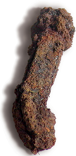
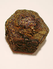
This is the only 'nut' found in the correct context on the site. Its location suggests that it may have been used on the inner rail. It may be one that got away during the telescope demolition.
Click here to enlarge>> |
|
|
|