 |
 |
 |
 |
 |
 |
 |
 |
 |
 |
 |
 |
 |
 |
 |
 |
|
|
|
|
|
|
|
|
|
 |
|
|
|
|
|
|
|
|
|
|
|
Grateful thanks to all those that have provided many of the articles, references and details in these pages
This is a non-profit site |
| |
| |
| |
| |
| |
| |
| |
|
|
Surveys of the Wandsworth Common
 Because the site was returned to common land after the telescope had fallen into disuse in 1871, there are no visible features remaining whatsoever. Because the site was returned to common land after the telescope had fallen into disuse in 1871, there are no visible features remaining whatsoever.
The method of removal and demolition in those days may not have been so thorough as it is today. Although many of the building materials of the tower would more than likely have been recycled including the bricks and the iron in the outer rail, it was hoped that the footings to the central tower may still remain hidden under the shrub or a little way under the ground.
|
|
|
 |
|
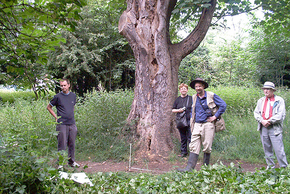
The very first cursory survey of the Wandsworth Common revealed much of the natural surface make up that would hinder our search. In the background to the left is the corner of Frewin Road with Lyford Road. It was the position and shape of the trees here that led wrongly to identifying this as the footings of the telescope's tower.
Courtesy Greg Smye-Rumsby
|
A cursory investigation of the area showed no indication of land features such as a mound that may represent parts of the buried remains. So it became obvious that the task was not going to be a walk over. If the central tower was to be located, there would need to be a full investigation, first of the history of this part of the common and then finding as many early maps as possible and fitting them to modern Ordnance Survey maps so that any small detail relevant to the telescope might be revealed. All this would take time. One of the biggest drawbacks, that would be wonderfully circumvented by Channel 4's Time Team Programme, was our need to secure permission to carry out an archaeological dig on the common.
back to top of page >>
|
|
|
|
|
| |
 |
|
|
| |
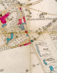
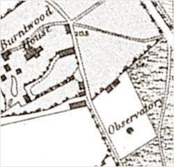
Part of the Stanford map of 1862 showing the Burntwood Estate and 'Observatory'. Compare the accuracy of the buildings with those in the later sales map. |
|
|
The Preliminary Surveys
Visual inspections in October 2002 and January 2003 revealed only vague and confused indications as to where the tower may have been. Several footpaths cross the site, some remaining virtually unaltered since the time of the ‘scope.
Those near the position of the tower as shown on the Stanford Map of 1862 were imbedded by copious amounts of ungraded flint "ballast", a typical building material of the time. It was thought that perhaps this was the spill from the "ballast sacks" during the tower's demolition in 1871; the sacks being used when the tower was in operation, piled onto its floors in the hope of damping down vibration.
Since, simply walking around the area was not going to be very fruitful it was decided that a full ground-penetrating survey be undertaken. So, in June 2003 a complete survey was done of the area around where it was thought the Craig Telescope once stood as shown on the Stanford Map. This was the only map at the time that showed any reference to the actual observatory tower and its location. By superimposing an Ordnance Survey Siteplan Data™ Map™ (TQ2773SW), it became clear that the scale of the tower as indicated, was wrong, being some 30-feet in diameter when scaled up, instead of the actual 15-feet. The only conclusion that could be drawn is that while the overall distribution of features was possibly sound, perhaps all the individual data points within the old map were wrong by as much as a factor of two or three! Accepting this as a possibility we could at least show that the observatory tower was positioned nearer the southern boundary of the site and that the observatory workshops were more or less along the northern perimeter - this being the back garden fences of the houses in Routh Road.
back to top of page >>
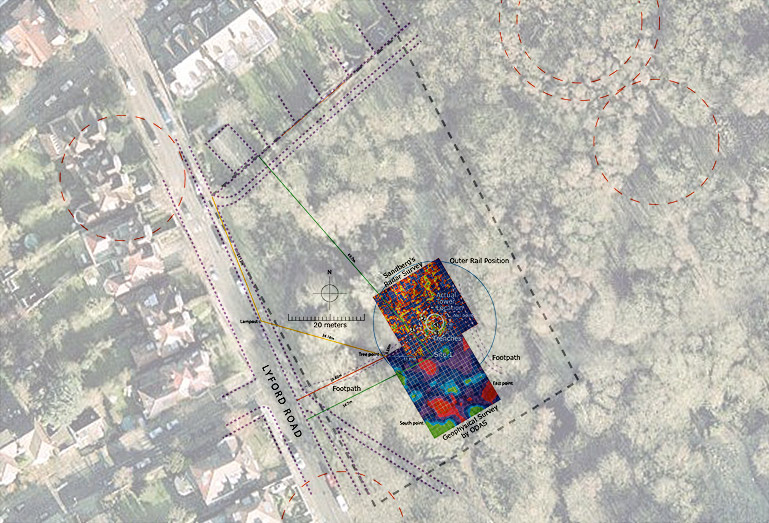
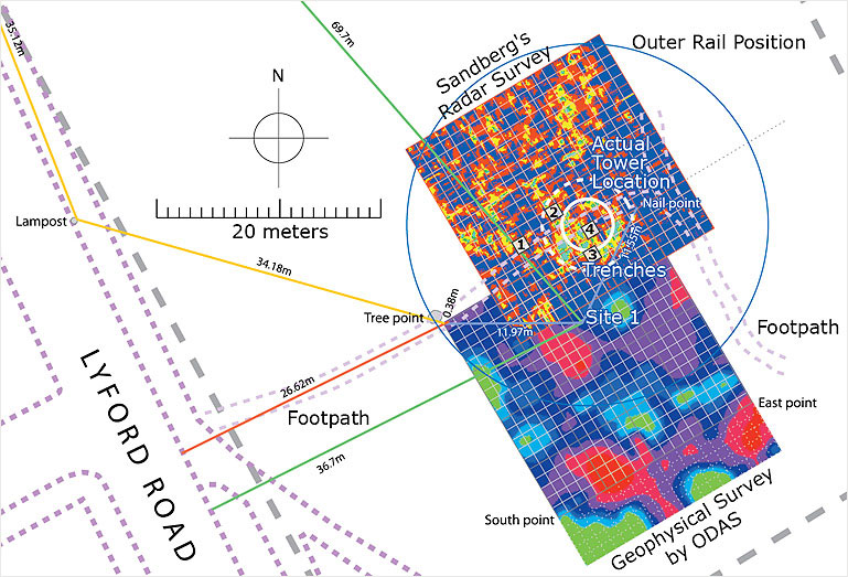
The Geophysical Survey
In the spring of 2003 it was decided that a geophysical "resistance" survey be carried out to see exactly what lay under the surface on this part of the Wandsworth Common. It was conducted by the Orpington and District Archeological Society (ODAS).
 |
|
The geophysical survey required a strict frame of reference from which to conduct as accurate a survey as possible based on the very limited information the team had available.
|
First, Dr Alan Hart of ODAS was given as much information as was available at the time, including all the mapping evidence, the engravings from the Illustrated London News and the copy of the only certain visual reference to the telescope at the time, the painting by G F Sargent. Dr Hart virtually discounted the Illustrated London News engraving as many of the features were clearly incorrect - the height of the tower compared to its width, the size and shape of the telescope tube and especially the diameter of the 52-foot outer rail, all cosmetically massaged in order to look good when published in 1852. The Sargent painting was much more revealing. Many of the details were relatively accurate including the placement of the outer rail. It also showed what appeared to be some kind of hard circular surface covering the whole of the site just beyond the outer rail.
Despite the amount of trees, shrubs and foliage (including great swathes of stinging nettles and brambles), a thorough survey was conducted.
It was necessary to set up a "most likely" target area which would be called "Site 1", in which it was hoped the remnants of the round tower would show as a clear change in the ground's resistance. A 20-meter by 20-meter grid was laid down on the ground over which the survey would be conducted. It was deliberately off-set from the supposed tower's position in order to take up any possible error and hopefully find the edge of the outer rail.
The result of the geophysics survey was, to some extent, disappointing, since it showed that the whole area was more or less uniformly laid with what appeared to be concrete with no noticeable change near "Site 1". But at least it did show, for the first time since the telescope stood on the Common, that the working site was covered in "something", and that "something" was hard.
The following weekend a physical survey was conducted using the same datum points used during the geophysics survey. The idea was to find out exactly what the "something" was and to find its edge if it had one. Perhaps by understanding the shape of this hard surface it might be possible to work out where its centre lay.
back to top of page >> |
|
|
Site Survey Plans and survey results
|
| It was assumed that this hard surface would end just beyond the outer rail of the telescope, forming a huge circular feature. By using a long probe made of metal it was possible to bore into the ground at given intervals near the assumed perimeter. However it became apparent that the hard surface was not round or if it was the flint gravel underlying the surface was confusing the issue. Indeed, it appeared to extend south, right down to the footpath opposite Herondale Avenue, way beyond the fenced perimeter shown on the "Indenture" map. Since this method was not going to reveal anything useful at this stage, it was decided to dig down to see what lay under the soil. So a number of small test trenches, the width of a spade, were dug just inches into the surface. Quickly, it was obvious that the whole area was covered in something equivalent to "type 1"; a hard porous surface, similar to that used in temporary car parks. It is relatively durable and prevents the surface from becoming muddy during use on wet days. |
|
See maps of the area through the years>> |
 |
Interestingly enough, only the small "spade" trench dug nearest "Site 1" revealed any artifacts. These consisted of small bits of broken brick and some old broken coloured glass bottles similar to those used for beer and wine in the middle of the 1800s. These were found just above the "type1" surface.
back to top of page >>
Some years ago a visit to the site by Stewart Mclaughlin, a keenly interested amateur astronomer who lived and worked nearby, revealed three short posts that appeared to be parts of the 52-foot outer rail. However, the Roads Department at the Wandsworth Council stated that these had nothing to do with the telescope. They had been put in some years earlier and then removed from the roadside paths, in a clean up operation to reduce footpath "clutter".
It is an interesting fact that at the site (and one has to assume that this was the case at the time of the telescope) the land slopes slightly downhill from west to east. In all the engravings and illustrations, the outer rail is shown as being more or less level with the ground - perhaps even inlaid. However, if this was indeed the arrangement, it must have caused many problems. Stones and gravel would have plagued the smooth running of the azimuth motion.
The bricks for the central tower of the telescope may have come from the same source as those of the Wandsworth Prison built only a few years earlier. These had come from the Frying Pan Brickworks not far from the site. If this was so then any masonry finds on the site that could be associated with the central tower may be the same as those making up the Wandsworth Prison today. A cursory investigation of the site showed no sign of any bricks lying on the surface.
An article written in 1856 mentions, "...surrounded by a wooden hoarding to keep off intruders". The fence shown in the engraving in the Illustrated London News was drawn from a daguerreotype photograph and so would suggest that the perimeter fence did exist.
Using some old maps, especially one created in 1862, not only is the two acre plot marked, but also a dark spot with the word "Observatory" written above! It is worth mentioning the two buildings on the northern boundary - each are about half the size of the present housing in Routh Road.
The 1870 map reveals no "telescope" marking. It may be that the telescope had been either removed or was in such a state as to be unrecognisable for any particular purpose.
The present day Ordnance map shows the modern day sprawl of the housing now occupying this part of the common. The properties in Lyford Road were built at the end of the 19th Century, while those in Routh Road are of an earlier period. Notice also the elevation contours showing the 30 metre height of the ground. The highest part of the site is the north west corner, although not by much.
No test trenches were dug near the locations of the workshops on the northern boundary of the enclosure as shown on the 1862 Stanford Map.
back to top of page >>
|
|
|
|
|
| |
 |
|
|
| |
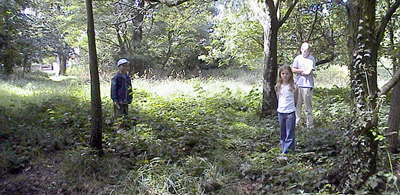
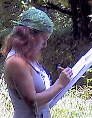
Rachel recording the much needed details of the site prior to our decision to do a full radar survey. |
|
|
A small team of volunteers was assembled consisting of Greg Smye-Rumsby, Craig Telescope Project Leader; Rachel, Craig Telescope Project Manager; Paul Smye-Rumsby, surveyor and Neil Howard, metal detectorist.
It was assumed that the hard surface would end just beyond the outer rail of the telescope, forming a huge circular feature. By using a long metal probe it was possible to bore into the ground at given intervals near the assumed perimeter. Unfortunately, shortly after starting, it became apparent that the hard surface was not round or if it was the flint gravel underlying the surface was confusing the issue. Indeed, by probing the ground more or less at random it appeared to extend south, right down to the footpath opposite Herondale Avenue, way beyond the telescope's fenced perimeter shown on the "Indenture" map. Since this method was not going to reveal anything useful at this stage, it was decided to dig down to see exactly what lay under the soil. So a number of small trenches, the width of a spade, were dug just inches into the surface. It was quickly realised that the whole terrain was covered in something equivalent to "type1"; a hard porous surface, similar to that used in temporary car parks (relatively durable and prevents the surface from becoming muddy during use on wet days).Interestingly enough, only the small "spade" trench dug nearest "Site 1" revealed any artifacts. These consisted of small bits of broken brick and some old broken coloured glass bottles similar to those used for beer and wine in the middle of the 1800s. These were found just above the "type1" surface. Neil Howard, the metal detectorist, was persuaded to carry out a survey that covered Craig's original two acres. Although it was not a focused search - without a full grid system laid out - it did prove quite useful in that it picked a number of artifacts. Some of these were associated with WWII - mainly in the form of shrapnel from the high explosive impacts. Some of the other finds were of unexplained origin, while others were more mundane including a long lost dog name tag. Some of the finds located near the pavement in Lyford Road may be attributable to the building of the houses there in and around 1910. It is interesting to note that in the opinion of Mr Howard, his detector sweep suggested that the area had not been subject to a demolition or if it had, it had been extremely well cleared away.
The Radar Survey
Because of the inconclusive results of the "resistance" geophysics, there was an urgent need to exploit another method of non-destructive surveying. Greg and his brother Paul discussed the matter at length and radar was suggested. Ground Penetrating Radar (GPR) uses radio waves to investigate underground stratas by the differences in their relative densities. But, since neither Greg nor Paul knew of anyone in the industry a search of the internet was made. The very first company in the search was Sandberg in Clapham. During a frantic phone call to the Managing Director it was mentioned that the Craig Telescope Project did not have any funds to pay for a GPR survey but that since the dig would be shown on television, the company's logo would appear on the hard hats that the dig team were wearing. Sandberg did not have the luxury of time to consider the matter since the Big Dig was to take place in less than a week. Within hours of the request, a call was received from Sandberg agreeing to the project's request - the Big Dig was on.
back to top of page >>
|
|
|
 |
|
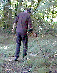
| Neil Howard, our metal detectorist, trying to find anything that might suggest the existence of a telescope. He did discover a long lost dog tag. |
|
|
|
|
| |
 |
|
|
| |
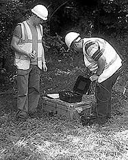
Seeing the tell-tale signs, Rachel looks on as a Sandberg engineer checks the data. |
|
|
So just two days before the Big Dig weekend, the GPR survey was undertaken. Like the geophysics survey, the GPR survey was in danger of being undermined by the very difficult terrain on this part of the common, so we knew the results might prove a little ambiguous. This second 20-metre x 20-metre survey was placed 5-metres east and 15-metres north of the "resistance" survey. An intuitive move, based solely only on the higher levels of resistance recorded at the northern edge of the first survey results, so if there was anything beginning to show up it would be more likely to reveal itself in the new survey. It also meant that there would be a 5 x 15-metre overlap on the two surveys for continuity.The results of the GPR were expected by late Friday, the day before the Big Dig – they came in on time. They showed two possible locations of the tower.
However, the chance of locating anything using this data was unknowingly thrown away during a routine enhancement procedure. Shortly after the results had been received from Sandberg, Greg Smye-Rumsby intended superimposing the GPR, "resistance" and ordnance data sets to make a single location map which could be used during the Big Dig to help understand all the possibilities open to us during the Big Dig weekend. But, unfortunately, during the enhancement the GPR was rotated 90°. This meant that the work of locating the tower was all that more difficult.The mistake was only seen after the actual dig itself, since, by another misfortune the error was spotted. For during a routine back up of computer software, the all important folder containing the finished results of the location maps had been inadvertently binned! This meant that the location maps had to be recreated using the original files. The GPR results were once again enhanced but because this time they had not been rotated, when they were laid down over the other survey and ordnance maps they fitted the dig results perfectly! The tower's location was assured.So the next step would have to be an archaeological dig. A dig that would normally have been impossible for novices and astronomers, but one that would take place by those very same individuals, through an opportunistic coincidence!
back to top of page >> |
|
|
 |
|
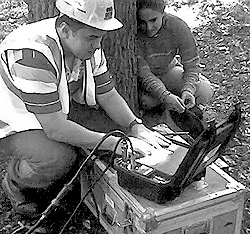
| Checking the equipment shortly before the radar survey. |
|
|
|